Still, go looking anyway. These range maps are usually made by looking at surveys conducted by various state fish and game departments (or for those department by various local herp societies). For instance, in my home state of Virginia, the Department of Game and Inland Fisheries (DGIF) has a map of the state, for each species, with counties highlighted where the species has been found. Most states have this. This is how authors compile their data to create these maps in their books. The trouble is is that just because a species hasn't been found in a certain county doesn't mean it doesn't exist there. In Virginia, there are curious areas where certain species apparently "don't exist" which lie between or among areas where the species is abundant. Fringe areas sometimes harbor the species in abundant numbers.
I live in Newport News, VA. I live in the "extreme" northern range of the Eastern Cottonmouth. Yet I know areas in my city where they are the most common snake, and found in such abundance that one had better watch his step. Yet they are considered rare here.
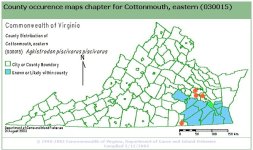
For example, here is a map from Virginia's DGIF showing the 'known" range of the Cottonmouth in Virginia. I live where the green dot is, a "known" county or city." Yet, I've personally seen wild Cottonmouths in the counties with red dots.
So, go looking anyway, you may be pleasantly surprised. better yet, you may find something just as interesting that you weren’t looking for.