• Hello!

    Either you have not registered on this site yet, or you are registered but have not logged in. In either case, you will not be able to use the full functionality of this site until you have registered, and then logged in after your registration has been approved.

    Registration is FREE, so please register so you can participate instead of remaining a lurker....

    Please be certain that the location field is correctly filled out when you register. All registrations that appear to be bogus will be rejected. Which means that if your location field does NOT match the actual location of your registration IP address, then your registration will be rejected.

    Sorry about the strictness of this requirement, but it is necessary to block spammers and scammers at the door as much as possible.

Official Daytona 2008 Thread

Yeah - I have been watching it. Current forecast puts it passing through Florida it looks like Tues-Weds. Hopefully it will make it through before the weekend.

For anyone flying down - definately keep an eye on it. The airlines will usually relax their travel policies due to severe weather like this. Even if it has passed through before the weekend - be sure to be at the airport extra early for your flights because there could be people whose flights were cancelled still trying to make it to Florida which could result in longer check in/security times.
 
At least it's early enough in the year that it probably won't do that hook and go across the state. Should be resolved one way or the other by Friday!

Floridians, do you know this link? It lets you spot them when they are way over by Africa, just so you know what's in the works, or what has disappeared, way ahead of time. http://www.nhc.noaa.gov/
 
I want one of those t-shirts that say, "I live in the cone of indecision"...

Guess I should add my hurricane watch site http://www.hurricanecity.com/ because I really like to watch the local radar, the web cams in the area affected, as well as the local news...
 
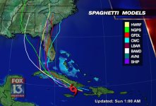
Here's a pic of a conglomeration of various modelling programs giving their predicted track for Fay.
 

Attachments

  • hurricane_track_models_1b.jpg
    hurricane_track_models_1b.jpg
    94.7 KB · Views: 89
from what they're saying, it should move towards Jacksonville and not directly hit Daytona, we should get the worst of it this Tuesday, prior to the show...
 
Brother.... Last time I looked at the forecast, it was predicted to hit around Naples as just a tropical storm. The weather *service* would probably be better off to just limit the forecast to no more that 24 hours out. Otherwise with the changes in predictions, they just get EVERYONE worked up over it as the path changes with each new iteration.

As long as it stays east of us, it shouldn't be too bad. When it goes west of
us, all the storms being brought up from the Gulf then slam into us.

Maybe I should have moved to Arizona.........
 
No, really, I like freaking out/relaxing every three hours based on the new track. Now she's heading for Kathy, ?Susan and Craig?, me, and Norm!
 
Latest forecast:

AL0608W.gif
 
Flying in Saturday is suddenly looking like a good thing!

While I don't mind flying, I prefer my feet on the ground. I've often thought, "I wish all my prayers could have the same intensity as the one I say when I'm sitting at the end of a runway."
 
Flying in Saturday is suddenly looking like a good thing!

While I don't mind flying, I prefer my feet on the ground. I've often thought, "I wish all my prayers could have the same intensity as the one I say when I'm sitting at the end of a runway."

I wish I weren't flying out of Greenville, SC--now I'll have to watch for flight delays. Hoo boy....
 
My dad isnt too excited about driving down Friday evening either. We leave after school and its going to be a very stormy drive! I will probably drive some of the way too...or maybe on the way home when its clearer.
 
Back
Top